To help future hikers doing the Walker’s Haute Route in late June/early July, I decided to write a blog post summarizing my experiences.
The Walker’s Haute Route is an approximately 115 mile trail from Chamonix, France to Zermatt, Switzerland. The trail starts with views of Mont Blanc and ends with views of Matterhorn, two of the most famous mountain peaks in Europe. The hike crosses 11 mountain passes and is considered one of the most beautiful backpacking trips in the world.
I heard about the Haute Route from two friends who had (independently) done it before. What really drew me to this trail was the fact that while you hiked demanding high alpine routes during the day, you stayed in dortoirs/inns/cabins in the evenings where there was always a hot three course French/Swiss meal waiting for you (for a Swiss price).
Pre-trip planning
I’ve included a list of all the gear I brought on this trip at the end of the post.
Guidebook
Kev Reynold’s book Trekking Chamonix to Zermatt: The Classic Walker’s Haute Route
It was quite overwhelming trying to figure out the stages of the trail (even remembering the names of the towns of challenging) just from Internet searching, so this book was absolutely critical. Buy it first and read/skim it first before you start planning. I brought it with me on the trip and often read it on the trail and the night before (especially when detours were necessary…) to figure out where to go. Plus it’s an easy signal to other hikers doing the same route as you to start a conversation!
Trip Reports
I read the following blog posts before/during my trip and found them helpful:
- Meandering Mayans
- Travels with Sheepy (my friend who crazily did the route in 6 days)
- Denver Davis
When To Go
If you want a more straightforward, stress-free trail where everything goes according to plan and as the guidebook describes, I highly recommend going at the end of July, August, or September when all of the snow has melted from the mountain passes. I went from June 29-July 10, 2018 because I had a conference in Zurich beforehand. I was hoping to get lucky with snow, but instead the Swiss had a great winter and there was actually more snow than usual at many passes, which led to some more difficult hikes, an introduction to mountaineering, and sadly a few detours. Going in early summer definitely makes the Haute Route more of an adventure, testing your on-the-fly trip planning and decision-making skills. The snow shifts parts of the trail a bit more from hiking to beginning mountaineering difficulty. If you do go in early summer, be prepared to hike on some snow and keep an open mind about the shape your trip may take. As my friend Brent wisely told me: “there’s no shame in turning back, YOLO.”
Transportation
Swiss public transport (train and bus) are famous for their reliability so that’s what I used to get around (ideally only a few buses to save time and skip valley walks, but unfortunately I also had to take a few trains to get around snow). The SBB trip planner website tells you the timetable and exactly which trains/buses you should take. Even better, I got the SBB iPhone app, which lets you search timetables live (I had free international data from T-Mobile) and you can even buy tickets in the app with a pre-loaded credit card and just display the QR code on board (even works for buses!).
Maps
Mostly I relied on Google Maps GPS and saved offline maps, but I figured I should veer on the safe side so I bought Swiss Topo 1:50,000 hiking maps:
at a bookstore in Chamonix and brought a compass.
I also highly recommend downloading the SwissTopo phone app, because it gives free access to all the Swiss Topo maps (up to 1:25,000 scale) when you have cell signal (which is quite often in Switzerland, although you shouldn’t rely solely on this), and lets you store a small area (about a day’s worth of hiking) offline for free. Of course you can also buy entire maps to store in the app too.
Weather
You can’t control it, but it’s still very useful to have accurate weather forecasts for the days ahead for safety and if you don’t want to miss the highlights scenery-wise due to clouds/rain. Everyone uses Meteo for weather forecasts, and another backpacker showed me the Meteo Swiss app, which is really useful: you can add multiple saved locations and the app shows you the multi-day forecast for all these locations on the same screen, which is great for Haute Route planning!
Personally I think the “highlights” vary highly due to your personal experience and weather, and you should just go with whatever you get. And I found the Swiss weather forecast is not quite as reliable as their train timetable, especially in the mountains, so don’t plan too much based on a weather forecast.
Itinerary
I did the Walker’s Haute Route finishing with the Europaweg in 12 days from June 29-July 10, 2018. I flew into Zurich earlier in the week for a conference, and I was flying out of Zurich on July 13. My plan was to hike in the Berner Oberland afterwards if I had time, but to give myself a few days of leeway for rain or rest. Since I was doing the trail in early summer and snow was a concern, I booked very little in advance so I could keep my schedule flexible. I often booked the previous day or even same day (though I booked Cabane de Moiry well in advance because I was told it was not to be missed). Perhaps because it was early season, I was still able to find a lot of great deals for private rooms in mountain village inns through Booking.com.
I was traveling alone, so I erred on the side of safety when making decisions. My mindset was to give anything a try and just be willing to turn back if it looked too dangerous. I also wasn’t an Haute Route purist; I didn’t feel like I needed to avoid all forms of public transit. I wanted to finish the route in as few days as possible, and valley/forest walks never really excited me, so my philosophy was to take buses/trains/cablecars whenever they saved me time or energy and no views were lost.
Day 1: Chamonix — Argentière — Col de Balme — Trient
The previous night I took trains from Zurich to Martigny and stayed there for the night. In the morning, I took the Mont Blanc Express train from Martigny to Chamonix. I had been to Chamonix three years ago, so the town was vaguely familiar to me. First I bought Swisstopo maps from a bookstore, then I went to the supermarket to buy some granola bars for today’s hike and a croissant for breakfast. After stopping at a macaron shop I’d been to three years ago for my morning ristretto and cafe creme (basically a deconstructed cappuccino where they give you a mini-pitcher of frothed milk for you to pour yourself), I starting on the route.
I actually had to take out the guidebook multiple times to read his directions because it was exceptionally confusing which way to go to leave town, both in Chamonix and Argentière (I lost over an hour walking in the wrong direction out of town). The hike was not so demanding, but it was the first day hiking with my full pack and 4L of water, so it took a while to get used to the extra weight. On the trail from Argentière to Le Tour there were actually a bunch of trail runners running the Mont Blanc marathon on the same trail I was hiking up! That looked super intense, and I made a mental note to look into trail running in the future.
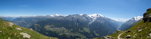
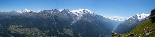
The hike up to the first mountain pass, Col de Balme, from Le Tour has great views backward of Mont Blanc (unfortunately the clouds covered most of Mont Blanc by the time I got to the pass). The pass is also at the French-Swiss border, so all villages afterwards were Swiss (though mostly French speaking). The hike up to Col de Balme seems like a popular day hike from Le Tour so there is plenty of traffic. It was a bit cold at the top of Col de Balme, and sadly the chalet was not yet operational (early season). I had made a reservation at the Auberge du Mont Blanc via Booking.com the day before; check-in ended at 7pm and I was a little short on time since I didn’t start super early from Chamonix and got lost a few times, so I took the direct route down from Col de Balme to Trient via Le Peuty. It was not that scenic, and I hustled to arrive at the inn just before 7pm. This was my first stop on the trip, so I only learned upon arrival that it’s common for these inns to serve dinner to everyone at the same time at 7pm. I had booked a private room (shared bathroom), which was only a little more expensive than a dormitory room, with half board (dinner and breakfast).
Dinner was soup, salad, tomato fondue with boiled potatoes, ice cream cake. This was one of my favorite dinners of the whole trip, particularly because the fondue, which had pureed tomato in it, was better than any fondue I’d previously tried. The inn assigned seats for dinner, and I met a very friendly Australian couple @nathankatesands, who were also just starting the Haute Route! Almost everyone else at the inn was doing the Tour du Mont Blanc (judging from their Kev Reynold’s guidebooks). Nathan and Kate told me they had descended Col de Balme via the alternative route via Refuge Les Grands, which had taken much longer because they had to cross multiple snowfields. This was the foreshadowing of many encounters with snow to come…
https://www.instagram.com/p/BknqriIHXLP
Day 2: Trient — Fenêtre d’Arpette — Col de la Forclaz — Alp Bovine — Champex
The standard route for the next stage was to go from Trient to Champex by crossing the Fenêtre d’Arpette (“window of Arpette”, another mountain pass). But a few days prior I had called the Champex Tourism Office and they said there was too much snow on the Champex (south) side of the Fenêtre to safely hike. In fact an Israeli hiker had died a few days ago attempting to descend. However, the Internet had also said that the views from the Fenêtre d’Arpette were “not to be missed” so I desperately sought a way to get at least some of those views. I called the Hôtel de la Forclaz to get more information; they also said crossing the Fenêtre was closed due to snow, but there was no snow on the Trient side, so it was possible to do a roundtrip up to the top from Trient.
The previous night in the Auberge du Mont Blanc, a guide for the Tour du Mont Blanc told me the entire crossing of the Fenêtre was dangerous, which brought me new uncertainty. But I figured I would wake up early, make my way towards the Fenêtre to see the conditions and go up to the top if it looked okay. Breakfast at the inn consisted of unlimited amounts of bread and jam, yogurt with muesli, and coffee – the perfect way to start any hiking day. At this point I had no food on me, so I had ordered a bagged lunch from the inn the previous night.
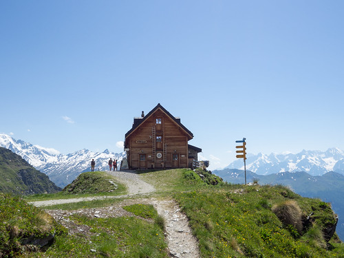
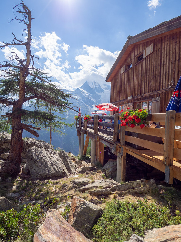
I made my way from Trient to Col de la Forclaz to the lovely Chalet du Glacier. This was my favorite chalet of the whole trip. I had arrived early in the morning, so there was a single woman there baking fresh fruit tarts. The smell of tarts wafted through the air, and the Glacier du Trient was in plain view. I asked the shop manager about the trail conditions, and she said that there was no snow on this side up to the Fenêtre, but parts of the trail were missing (probably washed out by snow melt?). She said it was possible to do the roundtrip if I was careful, and many people had done it in the past few days. This sounded optimistic, so I decided to give it a go. I bought a leftover slice of apricot tart to enjoy at the chalet before setting out, and I told myself I wouldn’t eat my bagged lunch until I got to the top.

Chalet du Glacier – the best place to eat fruit tarts
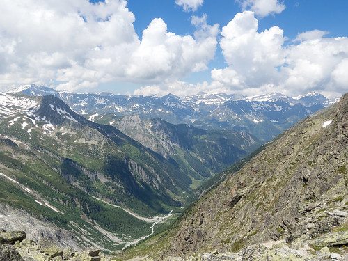
The ascent was quite strenuous, and there were two hairy situations where the “trail” was exposed and only wide enough for one foot at a time, due to parts of the trail being washed out. I crossed as carefully as I could with the help of trekking poles. Later I read in the guidebook that some parts of the trail were supposed to have ropes on the wall – nope, they were not there. The ascent ended with about an hour of rock scrambling, which was not dangerous but rather physical demanding, especially when the peak was in view but looked so far away. It took me 6-7 hours to ascend (longer than the guidebook estimated, probably due to trail conditions), while taking lots of pictures on the way. The entire ascent was dominated with close up views of the Trient glacier, which was really fascinating to behold. The view at the top is so worth it! After over an hour of looking at just rocks, a whole new view to the Arpette valley suddenly opens up before you. And looking back, you see the beautiful Trient valley, a view that accompanied me on most of the ascent but I never got tired of. I think the effort it took to reach the top really heightened my appreciation of the views and made the experience way more memorable.
Surprisingly, I was not alone at the top. There were two Israeli guys taking photos and having a lunch break; they said they had climbed up through the snow from the Champex side! They only had boots and trekking poles, no crampons or ice axes. But they did say it was dangerous and didn’t advise going down in the snow (there was a thick layer covering everything on the south side). I hadn’t eaten anything since the apricot tart, so I finally opened my bagged lunch consisting of a ham sandwich, apple, energy bar, chocolate, and water and enjoyed the views. While I was eating, a French/Swiss middle-aged couple who I’d seen at the Chalet du Glacier also came up. I told them it was dangerous to go down to Champex and they consulted the Israelis, but it looked like they were still planning to try descending in the snow with just poles.
After finishing my lunch, I descended the way I came back to Chalet du Glacier. Again some parts were hairy due to the lack of trail, and it took me 3-4 hours to get to the chalet. Sadly the tarts that had been baking in the morning were all sold out. Since I knew I still had a long hike ahead of me and would probably get to Champex after dinner time, I bought two sandwiches, tea, and dessert at the chalet. I saved one sandwich for dinner and ate the rest to recover my energy. While I was taking this break, I saw that the Israeli guys also successfully descended and were continuing on to Trient.
It was currently past 4pm and I still needed to get to Champex at night. Two days ago I had reserved a room at Hôtel du Glacier in Champex-Lac using Booking.com. By the time I got back to Col de la Forclaz it was 5pm, so I called the hotel (check-in ended at 9pm) and the manager told me he’d wait until 10pm but after that I was out of luck. So I rushed to take the alternate route from Col de la Forclaz to Champex via the 15 km “bovine” route (so called because you actually walk through a herd of cows). This route was also quite scenic (though not quite as astounding as Fenêtre) but I was super tired by the time I got to the hotel, 15 minutes before 10pm.
Day 3: Champex — Le Châble — Verbier — Cabane du Mont Fort
To save time and energy, I took the bus/train from Champex to Le Châble and then a cablecar up to Verbier. After buying two boxes of energy bars at the Co-op, I walked up to Clambin because I was hoping to eat lunch at the restaurant there. Sadly the restaurant doesn’t open in the early season, so I could only continue onwards. Somehow I managed to take the wrong trail and hiked up to Les Ruinettes on a mountain bike trail, which could have been dangerous. Luckily a mountain biker stopped me and pointed me in the right direction. In retrospect I should have just taken the cablecar from Verbier to Les Ruinettes as well, since the hike was not so scenic (although there were some nice views of Verbier and the frequent paragliders going down). The trail from Les Ruinettes was easy and only took an hour, with great views of the Combin massif. I arrived at Cabane du Mont-Fort in the early afternoon. I had booked a bed here two days ago by email, and I asked the manager at Hôtel du Glacier to call to confirm my reservation this morning. Since it was early season, they were not very full and I got a room to myself.
The outdoor seating area behind the cabin had panoramic views of the Combin massif. The cabin itself miraculously had cell service, free wifi (a little spotty), and electrical outlets in the rooms! You had to buy a token to take a 2 minute shower.
Dinner consisted of tomato soup, salad, spaghetti, and vanilla ice cream. During dinner, everyone at the hut was voicing concerns about the route to Cabane de Prafleuri because of snow. The hut guardian told me the standard route via Col Termin was closed, but the alternate route via Col de la Chaux was okay with just trekking poles and hiking boots. Another group said they had called a guide, who said he had led a group the day before, and it was possible but very slow, taking over 10 hours. I had no idea how much snow was on the trail, so I decided to start early the next morning and take a look, ready to turn back whenever the conditions looked dangerous or impossible.
Day 4: Cabane du Mont Fort — Col de la Chaux — Cabane du Mont Fort
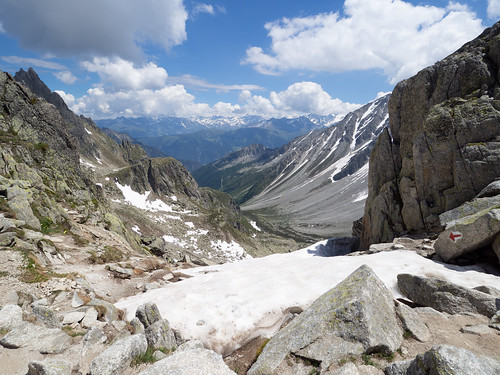
Today I got an involuntary free lesson in mountaineering. After breakfast, I left the cabin at 7am (giving the sun an hour to start softening the snow). The route via Col de la Chaux has a Swiss difficulty rating of T4, classified as an ‘alpine route’ with blue-white waymarks instead of the usual red-white (most hiking trails are T3). Keep in mind this is the rating when there is no snow. The entire ascent up to Col de la Chaux was covered in snow. As I got closer to the pass, I didn’t know where the trail was (the waymarks and trail were covered in snow) and I started walking uphill in a not-so-great direction. I was soon overtaken by a group of four (two women, two men) with mountaineering experience who clearly knew what they were doing more than me. I decided it was much safer to follow them than to try ascending on my own and getting lost. The ascent required using both trekking poles for anchoring and kicking boots into the snow to create shelves. After a scramble over rather loose rocks, we made it to Col de la Chaux and saw a snow covered bowl in front of us.
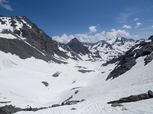
Because of the snow, we had to reverse descend (facing the snow) basically the same way we climbed up, using trekking poles. For context, I had never done this kind of climbing in the snow before. I could keep up on the ascent but was much slower than the mountaineers on the descent. They kindly waited for me to get down (which took forever), but told me that we had to clear two more passes (Col de Louvie and Col de Prafleuri) to make it to the hut. Just crossing one pass had taken more than twice as long as the guidebook estimated. For their own safety (to make it to the hut by nightfall), they said they could not afford to wait for me in the future. They said I could continue with them but I’d have to pick up the pace. They also suggested it was almost certainly easier if I turned around and headed back to Cabane du Mont Fort on my own. At first I wanted to stick with them out of sheer panic at the thought of having to climb a mountain alone, but the mountaineers were clearly faster than me and I was so tired from just one crossing I really didn’t think I could speed up my pace. So I decided to turn back. Unfortunately this involved recrossing Col de la Chaux alone. Again the ascent was no problem, but due to snow melt or just poor abilities on my part, I couldn’t find the trail we’d taken to ascend. But the mountaineers had taught me the basics (the most important rule is to always have three points of contact when you’re mountaineering!), so after first descending on more questionably unstable rocks, I slowly reverse descended in the snow by making a new trail (which was definitely not straight). It was slow going and demanded full body exertion, but it never felt dangerous.

The ascent and descent both looked like this.
I got back to Cabane du Mont Fort around 5pm and booked another night. There was plenty of availability and I was given a room to myself. At dinner, I met @nathankatesands again (they didn’t cheat and skip the stage from Champex to Le Châble like me). Dinner consisted of tomato soup, salad, macaroni baked with cheese and bacon, and a pear sorbet. Everyone else in the cabin was also doing the Haute Route: two Western Australian guys, a solo girl from New Zealand, a solo girl from Vancouver, and a group of older Spaniards. I told everyone about the conditions at Col de la Chaux. It turned out that the Spaniards were experienced mountaineers with proper gear so they knew what they were doing. Everyone else decided to skip the next two stages and make a detour by train the next morning. Tonight I paid for a shower.
I later found out that the mountaineers who had crossed Col de la Chaux made it to Cabane de Prafleuri in 12 hours, and it had started storming near the end – I’m very glad I turned back. The Spanish mountaineers took the route via Col Termin and [later] said it was a very tiring 10 hours. I met some other people later who also crossed Col Termin with mountaineering gear and a local guide (I think the route was “closed” due to risk of rockfall, but perhaps the guides can get around this).
Day 5: Cabane du Mont Fort — Arolla — Col du Riedmatten — Arolla
Six of us from the cabin woke up early and took the first cablecar down to Le Châble, then train to Sion. I experienced a Swiss train being late for the first time 😱. I was originally planning to take a bus/cablecar to Grande Dixence, near Lac des Dix, from where I would try to do part of the original stage from Cabane de Prafleuri to Arolla. However I missed the bus due to the train delay and the next bus wasn’t until late afternoon. So the solo Kiwi backpacker and I decided to take the bus from Sion to Arolla and do a roundtrip day hike in the reverse direction from Arolla to the top of Col du Reidmatten. On the bus I made a same day reservation for a room at the Grand Hôtel & Kurhaus on my phone using Booking.com. The hotel is right in the woods above Arolla with views of the mountains as a backdrop. The room was only $80 (the other backpacker got it for $60 the night before). I paid extra for the three course set menu dinner (there is also an a la carte option) of shrimp cocktail, lamb stew with tagliatelle, and fruit tarts.
It’s a shame that I missed large portions of the two stages from Cabane du Mont Fort – Cabane de Prafleuri – Arolla, which the guidebook said had some of the best views. I am already planning to return to Switzerland in a few years to do at least this part of the route again! I was also later told that the alternative stage to Cabane des Dix and the Glacier de Cheilon is highly worth a visit. In contrast, the Cabane de Prafleuri is only a necessary stop because there’s no other option – everyone said the owner was a “mean lady” who tried to wring as much money out of you as possible.
Day 6: Arolla — La Sage — Pointe du Tsaté — Col du Tsaté — Cabane de Moiry
The summary for today is that I’m terrible at navigation. After taking a bus from Arolla to Le Sage, I began ascending to Col du Tsaté. But somewhere along the route I completely missed a fork in the path and ascended all the way to Pointe du Tsaté (3077m). Only after walking around a while on an exposed ridge did I finally check the GPS and realize I was on the wrong peak. I had to descend back down to 2500m and re-ascend to Col du Tsaté.

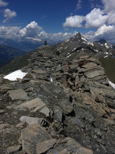
Walked around the top of Pointe du Tsaté for a while thinking I was supposed to “cross” the peak. Great views though!
It was already 4pm by the time I got to the top of the mountain pass, and as usual my source of stress was making it to the cabin in time for dinner. There was a snow field on the descent from Col du Tsaté, but I was able to avoid most of it by walking on the rocks at the edge of the snow. After arriving at the parking lot below Cabane de Moiry, I finally had to face some snow on the ascent to the cabin (the French version of the cabin’s website had mentioned there was still snow and rated the difficulty T3). The weather was sunny and the snow was soft by now. There were also ropes fixed to the wall, which made the climb up in the snow pretty easy. Finally, I arrived at the most high-tech cabin ever, sitting right next to the Moiry icefall, just as they were serving the main course for dinner (a little after 7pm). Dinner was soup, pot-au-feu (shared), and a lemon tart.
This was the most contemporary looking (and built) cabin I’d visited. It’s probably the newest/nicest mountain cabin in Switzerland. In terms of amenities, it was more like a normal cabin: no signal/wifi (you can get maybe 1 bar standing outside), coin showers, dorm bunk beds. The major marvel of the cabin is that you can see the Moiry icefall in exceptional detail either through the many large windows while eating dinner/breakfast, or on the deck outside whenever you want. I advise getting here early to maximize daytime inside the cabin to just eat and relax (they even offer afternoon yoga classes!).
Days 7-8: Cabane de Moiry — Barrage de Moiry — Zinal
The weather was rainy these two days and I was getting tired, so these were rain/rest days. On Day 7, I descended from the Cabane de Moiry in the morning the same way I came up. The snow was harder and more slippery, and the ropes didn’t help as much, so the descent was more difficult and felt a bit more precarious than the ascent yesterday. There was rain in the forecast and an Israeli hiker had told me at dinner yesterday that along the eastern route to Lac de Moiry, a wooden bridge at one of the stream crossings was broken, making the crossing potentially dangerous. So I decided not to take the direct route from Cabane de Moiry to Col de Sorebois, and instead I hiked to Barrage de Moiry, which is the dam for the lake, along the longer route to the west of the lake. I stopped at the restaurant at the Barrage for a coffee and ice cream. It started raining so I decided not to hike to Zinal via Sorebois. I was thinking of staying at the Chalet du Barrage (dortoir) near the restaurant for the night, but they were actually fully booked. Luckily I was able to book two nights in a private room with shared bathroom at Hôtel – Restaurant Le Trift in Zinal via Booking.com for the incredible price of $30/night! Cabane de Moiry had given me a free voucher that let me take the bus from Barrage de Moiry to the mountaineering village of Zinal.
The next day I took the cablecar back up to Sorebois and hiked to Col de Sorebois, which the guidebook said had “incredible panoramas”. The weather did not coorporate, and there was a wall of clouds the whole day so I didn’t see anything.


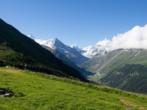
These rest days did allow me to experience life in a small Swiss village and eat lots of hearty food, which was just as pleasant as all the hiking. Zinal was probably my favorite town I stayed in on the trip (perhaps I’m biased because I spent the most time here and the hotel was so cheap). Zinal is in the Canton of Valais in Switzerland, and I ate at the Restaurant Le Trift in the hotel both nights, trying the very hearty and cheese-laden traditional Valaisanne dishes of Rösti (melted cheese on potatoes) and Croûte (melted cheese on bread). I definitely shouldn’t eat these every day, but they were perfect to re-energize me for the hikes ahead!
Day 9: Zinal — Hotel Weisshorn — Meidpass — Gruben — Grächen
Today was one of the best days of the trip! I decided to do the alternative stage from Zinal to Gruben via Hotel Weisshorn and the Meidpass (but skipping the overnight stay at the Hotel Weisshorn). There was an extra complication: yesterday I called the tourism office in Grächen and was told that the mountain pass Augstbordpass that I needed to cross the following day was closed due to snow. After much deliberation, I decided I would have to just take bus/trains from Gruben to Grächen that evening.
The walk from Zinal to Hotel Weisshorn did not disappoint (the guidebook said it had great views), with the sunny day bringing out a full array of blue, white, and green as I looked back at mountains in the Val de Zinal.
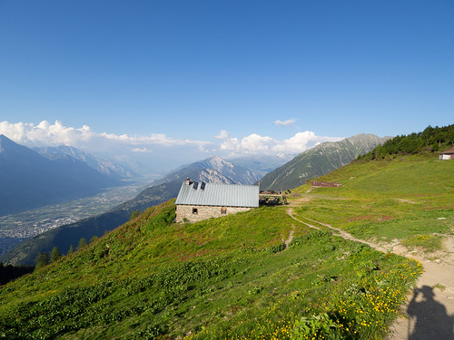
After a coffee/tart break at Hotel Weisshorn, I continued to the Meidpass, which has phenomenal panoramas of mountains, including the Bernese alps to the north. I had originally planned to go to Cabane Bella Tolla for lunch before getting to the Meidpass, but somehow I followed the signs that led directly to the Meidpass, which was probably good since the other route would have taken too long. Crossing the pass, I descended into the first German speaking Swiss village of Gruben. After an early dinner of rösti with veal sausage (which looked and tasted very different from the cheese rösti in Zinal) at Hotel Schwarzhorn, I took a series of shuttle/cablecar/bus/train to Grächen. Note: when booking public transport via SBB, the stop for Gruben is Gruben VS; there is another city named Gruben in Switzerland!
Grächen is a very pleasant resort town at a relatively high elevation (1615m) in the Mattertal, which is surrounded by numerous magnificent peaks. Out of all the Swiss villages I visited, it’s the one surrounded by the most number of impressive mountains. I highly recommend it as a quieter alternative to Chamonix or Zermatt. I reserved a private room for 2 nights at Hotel Eden the previous day using Booking.com. The hotel was run by a Swiss couple, and the wife was also the chef for the hotel restaurant!
Day 10: Grächen — St Niklaus — Jungen — Twära — Grächen
Since I didn’t cross Augstbordpass yesterday, today I decided to reverse hike from Grächen along part of the intended route to the Twära viewpoint, which the guidebook raves about for having breathtaking panoramas. I easily reached the viewpoint by taking a bus from Grächen to St Niklaus, a cablecar up to Jungen, and then hiking two hours. The views truly were the most awe-inspiring and memorable of the trip for me, with a row of snowy giants lined up to create an alpine wonderland.
At Twära I did meet several groups who did cross Augstbordpass, but they said it was a little difficult and involved several snow fields. While it would have been more satisfying to hike across such a large mountain range, and I think I would have been able to navigate the snow, I think I made the right call playing it safe since I was traveling alone. Plus everyone said there were no views at the pass, and the best views were definitely at Twära!
I returned to Grächen the way I came, saving energy to prepare for the Europaweg tomorrow. I had dinner at Hotel Eden tonight, which included soup, salad, a pork medallion with marsala sauce (?) and tagliatelle, and a very intricate ice cream dessert. I was very impressed that this was all cooked by the head chef (wife) and maybe two sous chefs (the restaurant was full of guests for dinner).
Days 11-12: (Europaweg) Grächen — Europa Hut — Täschalp — Zermatt
I was seriously debating whether to do the Europaweg trail, which is infamous for panoramas, constant exposure, and risk of rockfall. A friend of Brent had described it as “holy-shit-I-can-die-any-minute” and recommended skipping it (you can alternatively walk from Grächen to Zermatt via a low level route in 1 day). But in the end I knew I would regret it if I didn’t: after all the frustrating detours due to snow on this trip, the perfectly sunny weather was finally giving me a chance to finish the Haute Route on my own terms, and I wasn’t going to give up out of fear of the unknown.
While the risk of rockfall should be taken quite seriously, when the conditions are good (as they were for me), the trail is fun and stress-free, especially compared to some of the other challenges I’ve faced earlier on the route.
The first day of the Europaweg is dominated by views of the Weisshorn. It took me about 7 hours to get from Grächen to the Europahütte, where I would be spending the night. Since I decided to do the trail last minute, I had called to reserve a bed the day before. The hut was actually fully booked (there is an easy way up to it from Randa) but the warden said she would add a mattress to one of the rooms so I could sleep on the floor. The Europahütte had a clear close-up view of the Weisshorn, together with a patio to relax and enjoy the view on. Dinner was not the most impressive (perhaps personal bias, but I think the French side had better meals).
The next day I left the hut early, catching some really spectacular early morning views of the Weisshorn, with a golden hue from the rising sun – one of the best reasons to stay overnight at the Europahütte! Soon after, I crossed the Charles Kuonen Suspension Bridge, the longest pedestrian footbridge in the world! It was just built in July 2017 – hopefully it stays undamaged for a long time to come. The bridge was long but very stable, with almost no swinging while I walked on it (the shorter footbridge at the end of the route the day before was much more wobbly).
For most of the second day, the iconic Matterhorn takes over and is almost constantly in view, providing a dramatic conclusion to the Haute Route! As I got closer to Zermatt, the Matterhorn got closer and closer, but there was also a noticeable increase in foot traffic. While these spectacular views of the Matterhorn could easily be reached by a day hike from Zermatt, the approaching views of this iconic peak felt particularly exhilarating for me as they represented the culmination of an epic journey.
I booked a single bedroom at Hotel Jägerhof through Expedia two days ago. Surprisingly I got a free upgrade to a double room. The hotel had a very distinctive “woodland” decor but the rooms were very modern and well-furnished. The dinner was again mediocre except for the all-you-can-eat salad buffet, which was just what I needed after a long day of hiking.
Concluding Thoughts
The Walker’s Haute Route was a true adventure: adverse weather conditions (snow), on-the-fly rerouting, mountain cabins and villages, stunning views, and most importantly, the fellow travelers I met along the way. On this trip I was humbled: both by nature, with its incredible beauty and real dangers; and by other people – I was constantly outclassed by hikers of every age and gender. This is a walk that I will look forward to doing again in a few years.

Gear List
I brought everything with me, although some people send a suitcase from the Geneva airport to Zermatt or store it at a hotel in the city they are flying in/out of. This added a little extra weight from the laptop, but I tried to pack with the ultralight philosophy, so my pack weighed 20 lbs sans water.
- 1x Darn Tough Merino Wool Micro Crew Cushion Hiking Sock
- 1x Darn Tough Merino Wool 1/4 Cushion Hiking Sock
- 1x Smartwool Hiking Sock
- 1x Salomon Quest 4D 3 GTX Backpacking Boot
- 1x Flip Flops
- 1x Hyperlite Mountain Gear 2400 Windrider Backpack
- 1x Arc’teryx Beta SL Hybrid Jacket (rain jacket)
- 1x Arc’teryx Atom LT Hooded Insulated Jacket (mostly only used in early morning/night)
- 1x Smartwool Merino 150 T-Shirt
- 1x Smartwool NTS Micro 150 Pattern Tee
- 1x Ibex Woolies 1 Crew Longsleeve T-Shirt
- 1x Adidas Running T-Shirt for sleeping
- 1x Patagonia Quandary Pants
- 1x North Face Convertible Pants (only used as shorts)
- 2x ExOfficio Give-N-Go Boxer Briefs
- 1x Under Armour long underwear (didn’t use)
- 1x Nike Tennis Shorts for sleeping
- 1x Nike Running Shorts
- 1x Ibex Wool Gloves
- 1x Fleece Hat (didn’t use)
- 2x Bandanas
- 1x Platypus Big Zip LP Hydration Bladder 3L
- 1x Nalgene Water Bottle 1.5L
- 1x Black Diamond Spot Headlamp with extra batteries
- 1x Packtowl Ultralite Towel, Face Size
- 1x WILD-WIND Sleeping Bag Liner
- 1x Brunton TruArc 3 Compass (luckily I did not have to use)
- 1x Adventure Medical Ultralight & Watertight Series Medical 0.5 Kit
- 2x Aluminum Trekking Poles
- 1x Sunglasses
- 1x Sunscreen (so important) and Face Moisturizer
- 2x Swisstopo Maps
- 1x Kev Reynold’s Guidebook
- 1x Olympus OM‑D E‑M5 Mark II Camera
- 1x Olympus M.Zuiko ED 9-18mm f4.0-5.6 Wide-Angle Lens
- 1x Macbook
- 1x Booq Viper Hardcase
- 1x iPhone 6S / 1x Backup Smartphone
- 1x Kindle
- 2x A/C Adapters and Charging Cables
- 1x Portable Battery
- 1x Headphones
- Toothbrush and Toothpaste
- Eyeglasses and Contact Solution
- Purell
- Earplugs (important for cabins/dortoirs)
- Water Purifier Tablets (didn’t use)
- Plastic Grocery Bags (for groceries and to line boots in case of rain)
- Toilet Paper
Luckily you don’t need bug spray in Switzerland!